Naval Supply Depot &
Military Ocean Terminal
Bayonne, New Jersey |
| |
|
Harbor Location
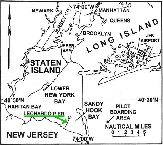
New York Harbor, located along the western shore of
Long Island, extends from the confluence of the Hudson and East Rivers in
the north to Lower New York Bay in the south. It includes Jamaica Bay to
the east and Sandy Hook Bay to the south. New Jersey ports of Perth Amboy,
Port Elizabeth, Port Newark, Bayonne and others are accessible through
tributaries which empty into New York Harbor. The harbor complex is
located between the New England lowlands and the Atlantic coastal plain.
Elevations range from sea level to a high of over 400 ft in the Richmond
area on Staten Island. Lower New York Bay is open to the Atlantic
Ocean in the quadrant from the east around to the south, while Long Island
Sound opens to the northeast. The Upper Bay opens to the south via the
Narrows to the Lower Bay.
The New York/New Jersey Port area is one of the largest commercial marine
complexes in the world. New York Harbor is a large, protected, natural
harbor located only nine miles from the Atlantic Ocean. Within the harbor
complex there are over 1100 facilities including over 720 piers, wharves
and docks (many inactive), good deep-water anchorages and an extensive
channel network. Entrance to the harbor is via a narrow man-made channel
which is difficult to navigate during heavy weather.
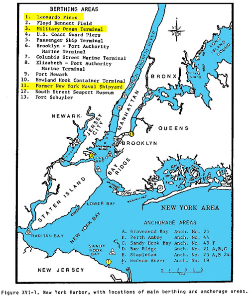
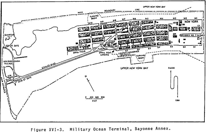
The Military Ocean Terminal, Bayonne, New Jersey, is located on the
western side of the Upper Bay about 15 miles from the entrance to Ambrose
Channel. There are ten northside (N1 through N10), seven southside (S1
through S7) and two east side (E1,E2) berths located around the terminal
peninsula. Northside berths are 570-633 ft long and 29-39 ft deep below
mean low water (MLW). E1 and E2 are 400 and 650 ft long, respectively, and
45 ft in depth below MLW. (Note: access to the terminal is restricted to
38 ft depth below MLW.) The south side berths are 28-37 ft deep below MLW
and 600-800 ft long; deck heights are 13 ft above MLW. The southern and
eastern berths are somewhat exposed to incoming seas through the Narrows.
|
| |
|
History of The
Peninsula Harbor at Bayonne
In 1932, some Bayonne businessmen made a basic plan to build a
Port Terminal off the east coast of Bayonne into New York Bay to create
additional industrial space. The plan was completed in 1939 and they
began dredging and filling.
Meanwhile, the US military became involved in World War II and the Navy
was looking for a location for a port on the east coast. The Navy was very
interested in this site for a large dry-dock and supply center. The
Bayonne military base was opened by the Navy in 1942 as a logistics and
repair base.
In 1967, the peninsula became a US Army base. It was a huge shipping
terminal and had the largest dry-dock on the eastern seaboard.
A unique strategic asset, Military Ocean Terminal, Bayonne, NJ [MOTBY]
sat astride the huge, highly developed, multimodal transportation network
of the American Northeast Corridor. No other
port on the east or gulf coasts, commercial or military, could duplicate
its combination of advantages in the support of power projection from the
continental United States without the disruption of commercial port
activities.
Once cargo arrived at MOTBY, it could be placed directly into vast
covered warehouses or uncovered--and fully secure--staging areas. All
types of cargo, from heavy, outsized weapons like the M1A2 tank and the
Patriot antimissile system, to the full range of munitions available to
our fighting forces could be loaded by Bayonne's specially trained union
force using state of the art, dedicated rail lines using every type of
roll-on/roll-off vessel in the MSC inventory. Bayonne had the best
steaming times to Europe, a full day's advantage over any other US port,
military or civilian. This capability was
amply demonstrated during the Gulf war and operations in Somalia and
Haiti. Dozens of units shipped through MOTBY as well as outsized
cargo such as M1A2 tanks from as far as Fort Hood, TX. |
| |
|
The End and a
New Beginning
MOTBY was a vast naval supply center. Ships carried goods from this
terminal for every major US military operation from World War II to the
Persian Gulf and Haiti mission in the 1990's. At its peak, MOTBY
employed about 3000 civilian and US armed services personnel and handled
more than 1 million tons of cargo each year.
With the end of the Cold War and lessened need for US military forces,
the federal government began closing down US military bases all over the
world. In 1995, the Base Realignment and Closure Commission (BRAC) voted
to close MOTBY despite strong opposition from local, state, and federal
officials.
In 1996, the Army had 2500 employees at the base, many of which were
civilians who lived in the area. These jobs were gradually phased
out over the next 3 years. Some employees accepted transfers to
other bases while others retired early.
On July 1, 1999 Colonel Charles Beck, commander at MOTBY since July
1996, turned the command over to Colonel William Black, the final
commander of the base. At that time, there were only about 300 employees
remaining.
The MOTBY flag was lowered for a final time during the closing ceremony
on Sept. 23, 1999. All civilian jobs were eliminated by Sept. 30, 1999.
On April 25, 2002, MOTBY was officially renamed The Peninsula at Bayonne
Harbor by the Bayonne Local Redevelopment Authority.
Plans for The Peninsula at Bayonne Harbor call for a vibrant mixed-use
waterfront development plan comprised of residential, light industrial
and office space. The site will also feature a marina with ferry service,
a public transportation station, a river-walk and numerous recreational
areas with parks and playgrounds. Royal Caribbean cruise lines
will begin shipping out of there on pleasure cruises in May 2004 and some
of the former military warehouses have been used for movie and TV
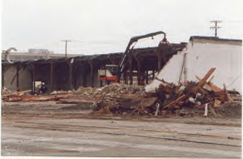
production during the last few years. There is a lot of demolition,
construction, and renovation going on there right now. |
| |
| |
 |
 |
 |
| |
|
|

Aerial view MOTBY |

Satellite Picture MOTBY |

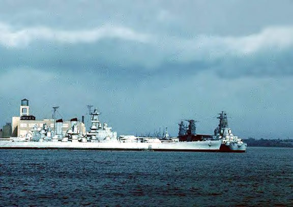
Reserve Fleet - 15 April 1953
Ships moored at the time were:
USS Alaska (CB-1), USS Guam (CB-2), USS North Carolina (BB-55), USS
Washington (BB-56), USS Fargo (CL-106), USS Albemarle (AV-5), USS
Wakefield (AP-21), USS Enterprise (CV-6), USS Franklin (CV-13), USS
Card (CVE-11), USS Croatan (CVE-25), USS Mission Bay (CVE-59), USS
Guadalcanal (CVE-60), USS Providence (CL-82), USS Little Rock
(CL-92), USS Spokane (CLAA-120), USS Fresno (CLAA-121) |
| |
|
|

Mothball Fleet - August '61 |
|
|
| |
|
|

Demolition of buildings - January 2001 |
 |
 |
|
|
|
|
|
| |
|
|
|
 |
|
Last updated: 06/01/04 |